Map-2026
Map – 2026
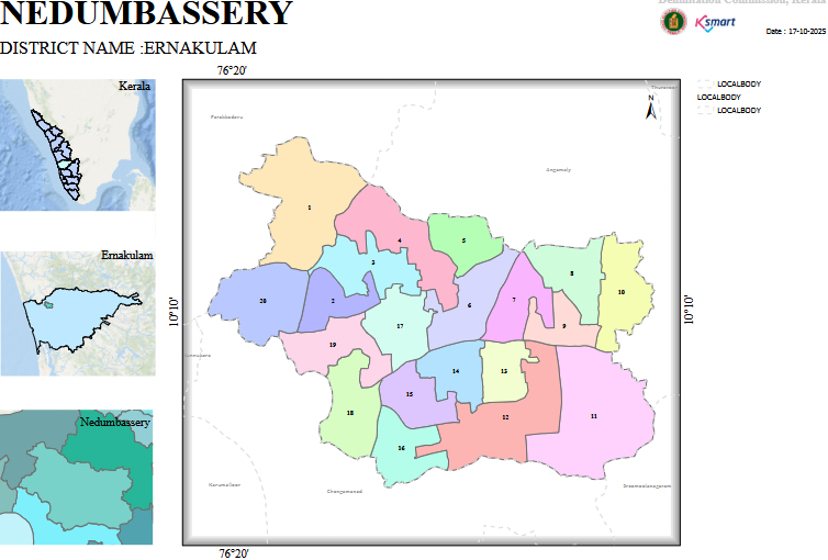
The image shows the ward map of Nedumbassery Grama Panchayat in Ernakulam District, Kerala. The map highlights the Panchayat boundary, ward divisions, ward numbers, and the geographical location of the Panchayat within the state and district.
Nedumbassery Grama Panchayat – Map Analysis Report
1. General Information
Panchayat: Nedumbassery Grama Panchayat
District: Ernakulam
Map Date: 17-10-2025 (as indicated on the map)
State: Kerala
The left side of the map indicates the geographical location of the Panchayat within Kerala State, Ernakulam District, and its local administrative area.
2. Ward Structure
- The Panchayat consists of 20 wards, numbered from 1 to 20.
- Each ward is represented using a different colour.
- Ward boundaries are clearly marked on the map.
- The geographical area of each ward varies, with some wards covering larger areas while others are relatively smaller.
3. Geographical Observations
- The central part of the Panchayat displays a more complex pattern of ward boundaries.
- Wards in the eastern and south-eastern regions cover comparatively larger geographical areas.
- Variations in ward shapes can be observed in the western and southern regions.
- The overall boundary of the Panchayat has an irregular geographical shape.
4. Administrative Significance
This map is useful for planning and implementing ward-level development activities.
- It helps in understanding population distribution and planning basic infrastructure development.
- It can be used for the geographical allocation of welfare schemes and public services.
- It serves as a basic reference document for election management and ward representation.
5. Key Information Obtained from the Map